


The land protected within Angle Fly Preserve has a history that has been traced back over 200 years to the early days of the United States of America. It forms part of an historic corridor in Somers known as the Mt. Zion Historic Neighborhood, which runs much of the length of Primrose Street/Rt. 139 and Plum Brook Roads, both pre-Revolutionary public roads. The name "Angle Fly Brook" can be found in early histories of the Town of Somers.
The Reynolds House sitting at the entrance to Angle Fly can be traced back to 1803 and may have replaced an earlier dwelling. An architectural historian has stated that the “core structure could be circa 1776.” When Somers Land Trust volunteers demolished the interior of the house in preparation for rebuilding it to house a caretaker, it was discovered that all the wood had been sawn by hand, possibly meaning it predates local sawmills.
Original Inhabitants
The Kitchawanks of the Mohegan tribe lived in the area. They likely used it as a hunting ground. Archeologists have found several pre-historic sites along the Angle Fly Brook.
Colonial Era
In 1667 this area was granted to Stephanus Van Cortlandt by King William III. Van Cortlandt was the first native-born mayor of New York City. The farmstead at the entrance to the preserve was one of five original homesteads on the west side of Primrose Street at the beginning of the Revolutionary War. During the war, farms were plundered by British troops and groups of outlaws, reportedly prompting one local farmer to drive his cattle into a swamp for protection.
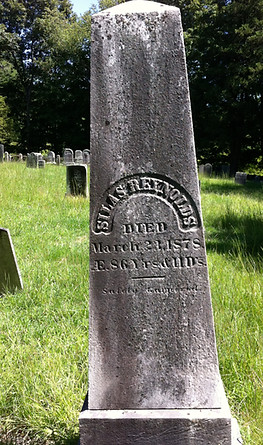
Silas Reynolds Farms the Land
In 1828 a White Plains speculator flipped the property, buying it in foreclosure for $750 and selling it for $2,900 to Silas Reynolds on the very same day! Silas Reynolds, for whom the house is named, was the son of James Reynolds, who fought in the Revolution and is buried near Silas in Mt. Zion Cemetery. Silas farmed this land for 50 years. Some of the Reynolds family had moved westward from Greenwich, Connecticut to Cross River, NY and eventually to Somers. Descendants of the Reynolds still reside in the area.
From Cattle to Apples
Grain was grown in the lowlands of Somers, while the hills were used for grazing. Cattle purchased from the north and west were fattened up in Somers to be sold in New York City. Although in the 1840's Somers voted to keep the railroad station out of town, farmers shifted to dairy and orchards, as the speedy new transportation enabled the marketing of perishable commodities. At one time this property was known as Somers Orchards and the neatly ordered trees can still be seen in aerial photos from 1928.
From Farm to Gentleman Estate
The Reynolds Homestead – 72 acres of current day Angle Fly Preserve – was sold to Edwin Tatham in 1905. The Tatham House on the hill overlooking the Reynolds House was built between 1908 and 1916, in Spanish or Mediterranean revival style. The house and its formal, walled garden reflect a time when a number of large farms were turned into so-called Gentlemen Estates. The Reynolds House then housed a series of caretakers for the estate.
In 1933, the estate was purchased by Warner Orvis who installed a pool house, a stone dam on Angle Fly Brook and showcase gardens. Some specimen trees still survive. He was said to have had a weeping wisteria, a highly invasive species. Wisteria now chokes much of the grounds surrounding the ruins of the house.
Series of Large Developments Proposed
Around 1970, after failing as a private hunting and fishing club, the estate was sold to Primrose Associates who combined it into a larger tract. In 1976 they built and furnished the models for the ill-fated 1,264 unit ill-fated condominium complex known as Primrose Farms. Ruins of model units and the sales office remain on the property. A second unrealized proposal for 278 homes followed in 1988. By 1997, the parcel found its way into the hands of developers who renamed the site Eagle River and proposed 108-homes with four miles of roads. As part of the Eagle River plan, the Tatham house and possibly the Reynolds House were to be razed.
Somers Votes for Open Space
An open space acquisition bond was passed by Somers voters in 2000, and the town formed the Open Space Committee to determine the most important open space parcels in Somers. Eagle River was high on the list. Grassroots efforts were launched by determined residents in a group called "For Somers" to protect this large and unique parcel – the largest remaining tract of open land in Westchester County. Outreach to the community included a memorable pair of before-and-after renderings of the site as seen from the historic Mt. Zion Churchyard.
Town, County, City and State Join Forces to Save Angle Fly
In 2004, following a report from the Eagle River End-Use Committee, the Somers Town Board made acquiring the parcel a priority. Westchester Land Trust and the Somers Land Trust helped facilitate an agreement to purchase the property that brought together funding from the Town of Somers, Westchester County, New York State and New York City. In May of 2006, Governor Pataki, Somers Town Supervisor Mary Beth Murphy and other officials stepped into the meadows of Angle Fly Preserve to announce the good news.
Somers Land Trust: Stewards of Angle Fly 2006-2023
Of course, the story doesn't end with the purchase of the property. Instead, the purchase was a wonderful beginning. Somers Land Trust was given responsibility by the Town of Somers to develop and maintain all 654 acres of the preserve. While working with partners to craft a management plan, SLT also needed to inspire people to get the site ready for the public. An informal group of volunteers called Friends of Angle Fly Preserve was created. Together with assistance from Somers Parks and Recreation Department, the Friends helped make sure Angle Fly Preserve would be ready for its official public debut on October 3, 2009. Instead of a large-scale development that threatened the local community and our watershed, Angle Fly Preserve is now open to the public for year-round enjoyment with over 10 miles of trails, composting toilets, a bridge over the Angle Fly, riparian forest restoration, and many scout projects.
Photos top to bottom: Silas Reynolds grave in Mt. Zion cemetery © Lauretta Jones, Reynolds House at start of rebuilding with non-original additions © Lauretta Jones, Reynolds House original structure revealed beneath several layers of siding © Lauretta Jones, Carpenters marks on hand-hewn beams in Reynolds House © Lauretta Jones, Swallow in a bluebird box,
© Peter Burckmyer, Wood frog emerging in spring © Mike Lubchenko, GoldStarPhotos.com, Promotional display for Primrose Farms © Lauretta Jones, Before and after renderings of Eagle River development © Anita Krusko, Somers Supervisor Mary Beth Murphy speaks at announcement of acquisition of of Angle Fly with Governor Pataki in background © Dan Simpson.